
Places to visit in Leiria region
Get to know the city of Leiria the place that was once inhabited by Suevi, Tulsus, Celtiberians, Moors, and Romans before the reign of Afonso Henriques, the first King of Portugal. The stones of the ancient Roman city were used in the Middle Ages to build part of Leiria. In the castle you still can see stones with Raman inscriptions. Leiria is located between the castle and the Lis River.
Interesting places to visit
1 – Leiria Castle
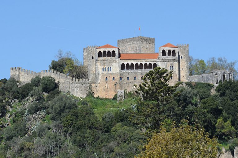
Classified as a national monument, it is the most emblematic construction in the city’s history. The architectural style of the Castle embodies 5 periods: the Romanesque of the 12th century, the Gothic Dionysius of the first half of the 14th century, the Gothic Joanino of the early 15th century, late 19th century and the first half of the 20th century. Currently, it is a pleasant place to go for a walk and sightseeing. A large part of the city can be seen from the top of the hill.
Address: São Pedro Square, 2400-235 Leiria – Portugal
GPS Coordinates: 39°44’51.1″N 8°48’31.0″W
More information: https://www.visiteleiria.pt/en/
2 – Leiria old town
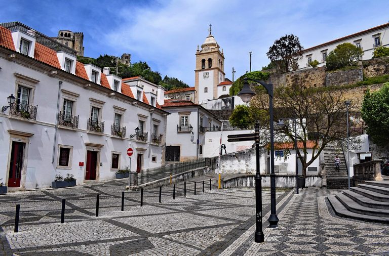
The old town is comprised of a beautiful and enriched architectural ensemble. Visitors can attempt to retrace the steps of Padre Amaro and Amelia, the central figures of the famous novel by Eça de Queirós, the famous Portuguese writer and diplomat. This place is a must-see as it has many stories to tell.
Address: Cathedral Square, 2400-175 Leiria – Portugal
GPS Coordinates: 39°44’45.5″N 8°48’25.8″W
More information: https://www.visiteleiria.pt/en/
3 – Rodrigues Lobo Square
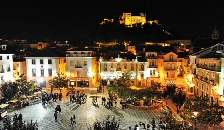
The square is located in the heart of Leiria and is named after the 16th century Leiria’s poet, Francisco Rodrigues Lobo. It is a beautiful place to see by day or night. At night the square has a vibrant night life with restaurants, cafes and bars, some with live music.
Address: Rodrigues Lobo Square, 2400-080, Leiria – Portugal
GPS Coordinates: 39°44’40.7″N 8°48’28.1″W
More information: https://www.visiteleiria.pt/en/
4 – Luís de Camões Garden
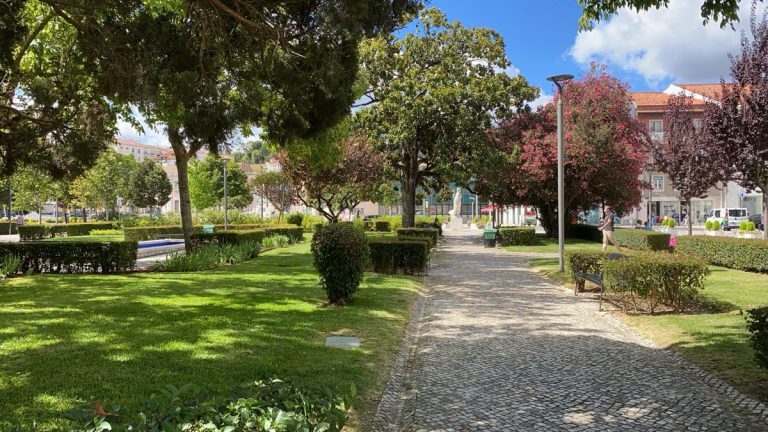
Located right in the city centre, this beautiful garden with flowers, lawns and sculptures, dates back to the 19th century. It is a suitable place to enjoy and relax in the city, to do sports or walk along the river banks.
Address: 5 de Outubro Square, 2400-137, Leiria – Portugal
GPS Coordinates: 39°44’38.6″N 8°48’24.9″W
More information: https://www.cm-leiria.pt/
5 – Sant’ana Market
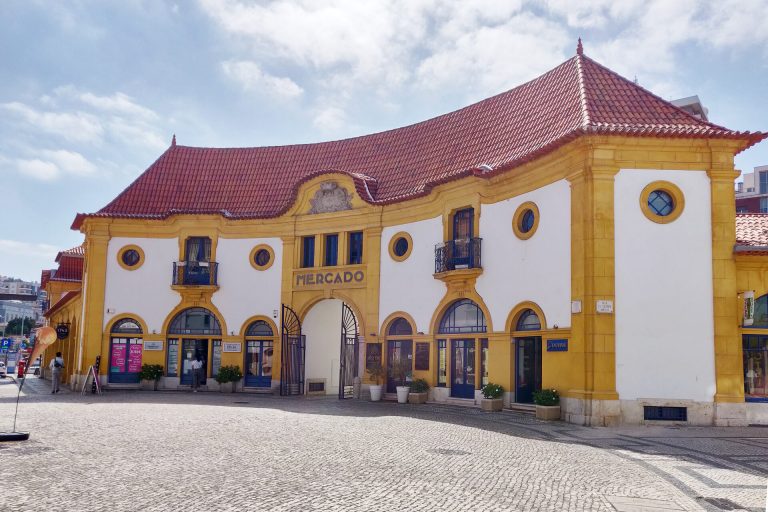
The building, dating from the early 20th century, was restored by the local famous architect Ernesto Korrod. It used to house the Municipal Market of Leiria. Currently it became part of the cultural center, and serves as a meeting place for locals.
Address: Santana Square, 2400-120, Leiria – Portugal
GPS Coordinates: 39°44’35.6″N 8°48’27.1″W
More information: https://www.visiteleiria.pt/en
6 – Penedo da Saudade Lighthouse (São Pedro de Moel)
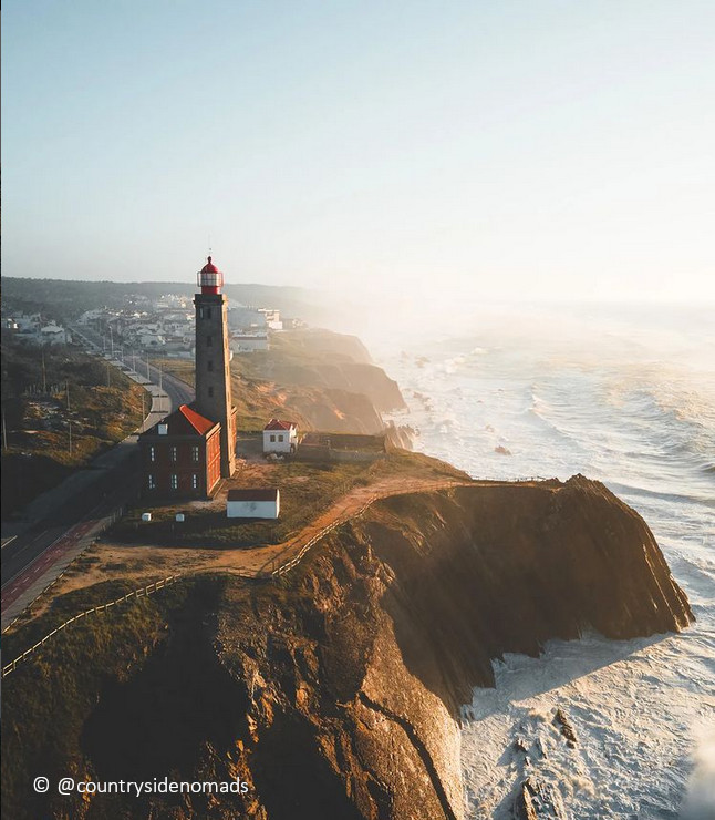
The Penedo da Saudade Lighthouse (Portuguese: Farol do Penedo da Saudade) is located on the Atlantic coast in São Pedro de Moel, District of Leiria, Portugal. The rocky outcrop overlooking the ocean takes its name after the mournings of a Duchess from the 17th century, that grieved the execution of her husband. The legend claims that the rock still resonates with her lament. The functioning lighthouse was built in 1912 and takes its name from the cliff on which it was constructed. São Pedro de Moel is a beach community, located within the Pinhal de Leiria, west of the cities of Marinha Grande and Leiria. The unique landscape of the small village, with modernist architecture is worth visiting.
Address: Avenida do Farol 2430, Marinha Grande – Portugal – Portugal
GPS Coordinates: 39°45’52.1″N 9°1’41.6″W
More information: https://www.amn.pt
7 – Nazaré
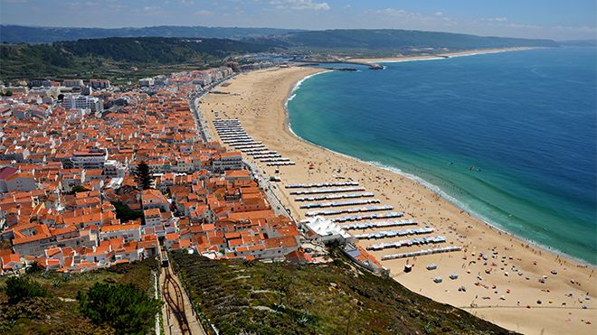
Nazaré beach, with its mild climate and natural beauty, has one of the most ancient traditions connected to fishing in Portugal. Facing the sea on the right, you will see an impressive headland. This is Sítio, which provides one of the most famous views of the Portuguese coast. It is a 318 metre rock face with a sheer drop to the sea, and is reached on foot by the bravest, or by going up the funicular.
These days, Nazaré’s major attractions are the waves and surfing, thanks to the “Nazaré Canyon”, a submarine geomorphological phenomenon that allows the formation of perfect giant waves. It is the largest underwater canyon in Europe, about 170 kilometres along the coast, reaching a depth of 5,000 metres. The Hawaiian surfer Garrett McNamara received worldwide publicity when, in 2011, rode the biggest beach-breaking wave in the world, about 30 metres high, at Praia do Norte.
Address: Estrada do Farol, 2450-065 Nazaré – Portugal
GPS Coordinates: 39°36’19.1″N 9°4’32.6″W
More information: https://www.visitportugal.com/en/
8 – Monastery of Batalha
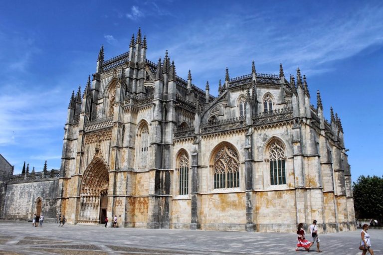
Monastery of Santa Maria da Vitória (or Monastery of Batalha) On 14 August 1385, close to the site of the monastery at Batalha, an event took place that was to prove decisive for the consolidation of the Portuguese nation. This was the beginning of a project whose construction work would last for almost two centuries and resulted in one of the most fascinating Gothic monuments in the Iberian Peninsula. Its great architectural value and historical significance led to the building being classified as World Heritage in 1983. A visit to the monastery’s interior is, of course, mandatory, but, if possible, do not miss the great spectacle of the monastery’s night-time illumination, which greatly enhances its exuberant beauty and gives the carefully carved stonework a look of genuine magnificence that you will never forget.
Address: Largo Infante Dom Henrique, 2440-109 Batalha – Portugal
GPS Coordinates: 39°39’35.1″N 8°49’21.9″W
More information: https://www.centerofportugal.com/
9 – Monastery of Alcobaça

The monastery was built at the same time as the foundation of Portugal as a nation, and also shares some of its history. The Cistercian Order was founded by the Portugal’s first king, D. Afonso Henriques, following the donation of lands in Alcobaça in return for victory over the Moors during the conquest of Santarém. Building on the monastery began in 1178, following the model of the abbey of Claraval, the Order’s mother church in France. The monks, who traditionally wore white habits, created a unique work of civilisation in the region, reflected in the public school that was founded in 1269. Make sure to visit the impressive set of mediaeval buildings, including the refectory, dormitory and chapter room, together with the cloister of D. Dinis, the surprising kitchen and the King’s room.
Address: Praça 25 de Abril, 2460-018 Alcobaça – Portugal
GPS Coordinates: 39°32’54.2″N 8°58’45.4″W
More information: https://www.centerofportugal.com/
10 – Fátima
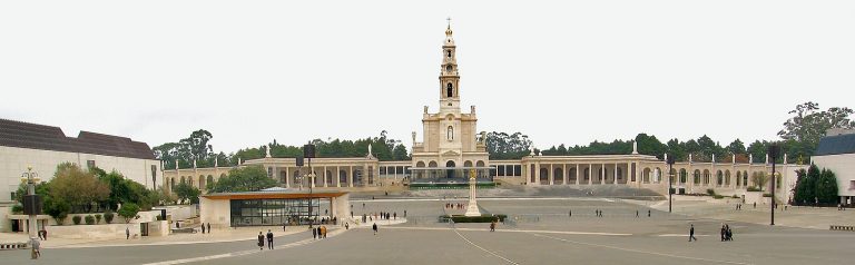
Fátima is a civil parish in the municipality of Ourém (Santarém). Until 1917, Fátima was an unknown village which was build in an open field, used for pasture and rain-fed agriculture. It became known worldwide for the Marian apparitions to the three shepherds which took place between the 13th of May and the 13th of October 1917. The construction of the Sanctuary of Fatima stimulated local development and the town of Fatima was elevated to the status of city on 12 July 1997.
Address: Av. de Dom José Alves Correia da Silva, 2496-908 Fátima – Portugal
GPS Coordinates: 39°37’52.6″N 8°40’22.4″W
More information: https://www.visitfatima.pt/en